Hola Todas,
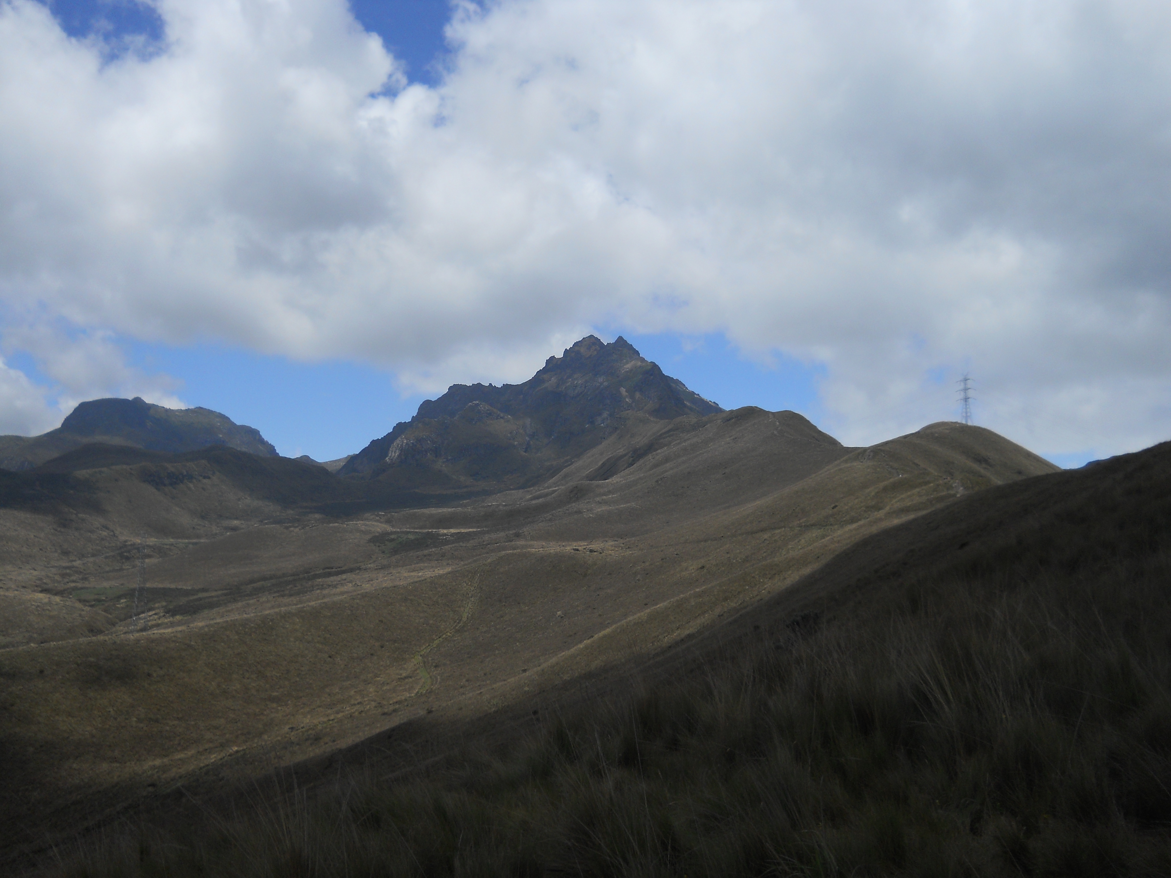
It has been a while since I have checked in with you fine folks so I thought my sick day could be used to update everyone. Last Saturday I completed something that I had been wanting to do since I arrived in Quito which was climb Volcano Pinchincha. A little background on Volcano Pinchinhca. Pinchincha has two major peaks Guagua Pinchincha(15,696 ft) which means child in Quechua(ancient indigenous language of the Andes) and Rucu Pinchincha(15,413 ft) which means old person in Quechua. Guagua Pinchincha is the active part and last erupted in 1999 covering Quito in several inches of ash. Quito is located on the slopes of Pinchincha and if there was a major eruption there could be massive problems.
Now back to the story at hand. I woke up a little chuchaqui(quechua for hungover) from a night out on the city and thought about falling back asleep but decided to stick with it. I met up with Buddy(yes that is his name) at Quicentro, the local mall, with my backpack filled with my jacket, 3 liters of water, and my ham and cheese sandwich my host mom made me. We took a short 2.50$ taxi ride to the Teleferico to take the cable cars up the mountain. The ride up the Teleferico costs 8.50 for non Ecuadorians and around 4 bucks for Ecuadorian citizens. The Teleferico raises from 2 950(9,675 ft) meters up to 4 050(13287 ft) meters in 10 minutes. The ride offers great views of the surrounding mountains and of Quito, it also gives you your first experience with altitude sickness as your body experiences rapid altitude change. I felt fine besides for a slight headache which was probably from the hangover. We arrived at the top and explored the little park they have at the top which includes a restaurant, a little church, and a little museum. We didn’t waste too much time before we started our long ascent to the top of the peak. P.S. there have been to known to be robbers that are on the trails so make sure you go with at least one other person to ensure safety.
In the first 10 minutes we found the stable of horses that you can rent to explore the area or take you to the base of the mountain, but we wanted to hike the whole way and continued on. We soon discovered that our lack of cardio stamina combined with the extreme altitude was having an effect on us. At the top of each big hill we had to stop and catch our breaths, slow down our heart rate, and keep drinking water. Make sure you stay hydrated or you are going to have a bad time! Suncreen is also a most, the thin air and proximity to the Ecuador makes burning very easy, even if there are clouds. We just kept on trucking at a slow and steady pace while looking at the amazing views of the valleys, mountain peaks, and Quito. The first part of the trip consisted of a long trail of rolling but verily steep hills as you get closer to the prominence of the mountain. After around 2 hours of hiking we reached the base of the mountain and decided to stop and enjoy our almuerzos(lunches) of a sandwich for me and bread for Buddy. Poor college students ftw!
After we finished we continued our trek around the backside of Rucu Pinchincha, This is where the trail gets a little narrower, involves climbing over rocks, and at times sharp drop offs to the side where you wont survive the fall. We finally came to the famous sandy slope which signified we were close to the summit but still had a lot of work to do. There are two trails to reach the top of Rucu Pinhcinhca the first involves walking up the very steep sandly slope(around 50 degree slope) for about a .2 of a miles or take the longer but easier switchback trail. We ran into some Ecuadorian guys who had passed us earlier and we followed them up the easier switchback trail. Halfway up the trail kind of disappears as it becomes straight rock. This was when Buddy and I were happy we were with the Ecuadorians, who had climbed it before and therefore knew the way through the labyrinth of rocks. We arrived at a steep cliff that offered amazing views, so we stopped for some pictures and relaxed for a bit before the final ascent. After about 10 more minutes of crawling on all 4s we finally reached the summit of the mountain!
The views were amazing on the top of the peak. I had climbed to an elevation of 4696 meters(15406 feet) and felt a huge sense of accomplishment. That is over 7.5 times higher than Blacksburg’s eleveation! The summit offered amazing views of Guagua Pinchincha, the active stratovolcano, the valley below and parts of southern Quito. The side we had summited became enshrouded by fog, it was a surreal moment. The one side was clear as day and it was as if a invisible forcefield held back the fog on the other side. Over to the left it seemed like I was in an airplane as I could see blue skies above me and a layer of clouds only a few hundred feet below me. There were also two blackish birds with orange beaks(cant remember their names) that landed on the peak not 20 feet from us which was really cool also. After the necessary pictures we starte our descent.
After scrambling down the rocks on hands and legs, and without cutting my hand open, we came to the famous sandy hill again. This time we went down the 50 degree slope part. This was one of the funnest parts of the trip. While descending you pretty much sprint/slide down the sand, aka “Sand-Skiing” the newest sport to sweep the nation. While doing this make sure you keep your weight back, its okay to fall on your butt, not on your face. Also cuidado with the random huge rocks in the middle of the trail. The rest of the trek down was pretty uneventful and takes about half the time as the ascent. We met some cool Portuguese people and an Italian man who were a little bit older than us. They all spoke 4 languages fluently, some people have all the luck! We also encountered mountain bikers who enjoy biking down the dangerous trail down to the Teleferico. On the hike down we were also able to see Volcano Antisana in the distance over Quito. It was a snowcapped mountain that is over 18000 feet high, I dont think I will mess with that one.
We finally reached the Teleferico after around 5 hours of hiking. 3 hours up and 1.5 back(breaks involved). We hiked around 6 miles and ascended over 2000 feet. This was definitely one of the more challenging physical experiences of my life but also one of the most exciting and rewarding. I suggest attempting this difficult but enjoyable climb if you are in Quito one day of your lives.
There are around 70 photos of my hike of Rucu Pinchincha on my Facebook Photo Album “Ecuador”
Well thats all for now from the Gringo en Quito
Thanks for reading everyone
Jesse